Český Krumlov District (Okres Český Krumlov)
The area was the hereditary home of the Rosenberg (Rožmberk) family, Lords of Krumlov and Rozmberk.
Benešov nad Černou - Besednice - Bohdalovice - Brloh - Bujanov - Černá v Pošumaví - Český Krumlov - Dolní Dvořiště - Dolní Třebonín - Frymburk - Holubov - Horní Dvořiště - Horní Planá - Hořice na Šumavě - Chlumec - Chvalšiny - Kájov - Kaplice - Křemže - Lipno nad Vltavou - Loučovice - Malonty - Malšín - Mirkovice - Mojné - Netřebice - Nová Ves - Omlenice - Pohorská Ves - Polná na Šumavě - Přední Výtoň - Přídolí - Přísečná - Rožmberk nad Vltavou - Rožmitál na Šumavě - Soběnov - Srnín - Střítež - Světlík - Velešín - Větřní - Věžovatá Pláně - Vyšší Brod - Zlatá Koruna - Zubčice - Zvíkov
Part of the district territory belongs to Boletice Military Training Area.
Map - Český Krumlov District (Okres Český Krumlov)
Map


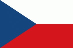
Country - Czech_Republic
 |
 |
| Flag of the Czech Republic | |
The Duchy of Bohemia was founded in the late 9th century under Great Moravia. It was formally recognized as an Imperial State of the Holy Roman Empire in 1002 and became a kingdom in 1198. Following the Battle of Mohács in 1526, the whole Crown of Bohemia was gradually integrated into the Habsburg monarchy. The Protestant Bohemian Revolt led to the Thirty Years' War. After the Battle of White Mountain, the Habsburgs consolidated their rule. With the dissolution of the Holy Empire in 1806, the Crown lands became part of the Austrian Empire.
Currency / Language
| ISO | Currency | Symbol | Significant figures |
|---|---|---|---|
| CZK | Czech koruna | KÄ | 2 |
| ISO | Language |
|---|---|
| CS | Czech language |
| SK | Slovak language |